An improvement whose time has come We always aim to keep the layout of the app as simple as possible. Consequently, separating the weather map and the search made sense.
But as we have been adding more features, there are many cases where it would be practical to have a search option available in the weather map and vice versa.
Therefore, all search functions and features are combined into the wind map. We’re also updating the map menu with more display options so that you can adjust the look and feel of the map according to your needs and preferences.
What changes
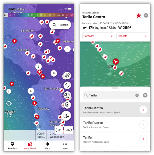
Search on map We are adding a new button in the top right corner of the map view. Tapping this button toggles the search – simple, isn’t it?
Search results will be displayed as a list, just like before. Tap a search result to reveal its location on the map or to jump directly to weather forecasts and measurement data.
Labels and markers for places, favorites, and Windfinder spots All markers and labels for spots and places will be available on the map. In addition, the markers are adjusted for simplification and a better overview.
We are adding options to hide (or show) these spots, places, and favorites to the map menu. This way, the map is always as dense or lightweight as you want.
New bottom bar navigation We have designed the new navigation symbol to communicate that search and map have been combined.
What doesn’t change
Everything else remains the way you know it.
When it is available
Very soon.
Thanks for reading! As usual, we welcome your feedback or any suggestions you may have to make the Windfinder app better. You can reach us by simply sending an email to support@windfinder.com or using the feedback option in the app. We look forward to hearing from you!
We are constantly working on improving our beloved app and have added some new features for you!
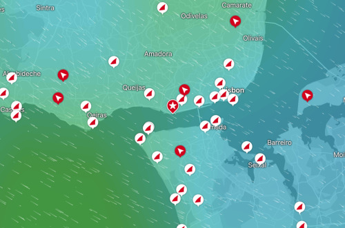
Labels All 120,000 cities, districts, small towns, and villages with more than 1,000 residents are now tappable labels on the search map with detailed wind and weather forecasts. Just tap on it and make it your favorite!
Windfinder Spots For a fresh look and more consistency, we have given the Windfinder Spots and spot clusters a design overhaul. With better contrast to the map, the location selection is now easier and more intuitive.
We value your feedback and welcome any suggestions you may have to make the Windfinder app better. You can easily reach us by tapping the feedback button in the app or by sending an email to support@windfinder.com. We look forward to hearing from you!
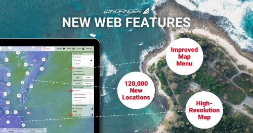
What is new We’ve added labels for more than 120,000 cities and towns and given the Windfinder Spots on the map a major overhaul. The improved map menu and our new high-resolution map make navigating our weather map now easier than ever!
The Map Our brand new high-resolution wind map with relief displays real topographical conditions. Hills, mountains, and valleys are now visible on the map. With the high-resolution wind forecast, you will see on the map how the wind flows through canyons or is deflected by islands in the sea. It enhances your visual experience making it easier to track changes in weather patterns.
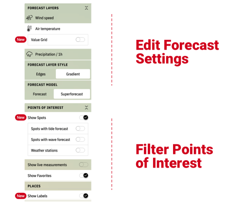
New Map Features We have slightly reorganized our map menu for easier use and added new features. The menu is divided into forecast settings and filtering options for points of interest. Use the toggle switches to customize your forecast map. Keep on reading for more details.
Labels Cities, districts, small towns, and villages are displayed as clickable labels on the map with detailed wind and weather forecasts. States and associated sub-areas, such as federal states, are also displayed as clickable labels and reposition your screen view for better orientation. Use the toggle switch to activate or deactivate the labels on the map.
Windfinder Spots Specific points of interest that may be relevant to you are Windfinder Spots. These include local infrastructure, such as airports, marinas, beaches, and buoys. More importantly, many Windfinder Spots are places suitable for water- and wind-based sports and activities. Discover spots for your home and holiday sessions directly on the map and make them your favorite by tapping the star icon. Click on “Show Spots” to see your filter options and the Windfinder Spots on the map.
Spot Cluster Depending on the zoom level of the forecast map, nearby Windfinder Spots are grouped into spot clusters. The clusters help you navigate the map by giving it a clearer look. Click or tap these cluster icons to zoom in until individual spot markers appear.
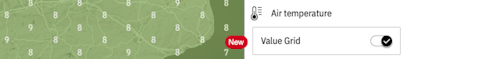
Value Grid See the air temperature and precipitation in a value grid to get the exact temperature or precipitation for your area, making the forecast on the map easier to read.
More places, more details, easier to use.
Thanks for reading! We hope you’ll like our new features as much as we do!
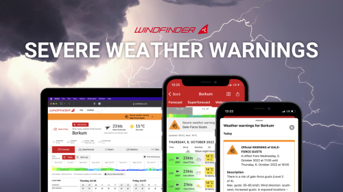
Our latest feature provides you with comprehensive severe weather warnings for Europe and the U.S. - based on reports from the National Oceanic and Atmospheric Administration (NOAA) and Meteoalarm, a network of European national weather services.
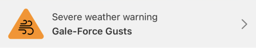
In case of a predicted event for your selected spot, a preview warning will be displayed on the spot page or forecast screen. By clicking or tapping on the warning, you will get a detailed description of the event and its impact, including instructions on how to stay safe during this hazard.
The warnings are structured in a multi-level system. Hazard icons indicate the type of severe weather, while the intensity of the event is indicated with a color code ranging from gray (minor) to red (devastating).
If multiple warnings are displayed for one location, the most recent or the one with the highest warning level always applies!
Be prepared at all times and take the necessary precautions with Windfinder’s latest feature!
Out now for Android, iOs (Windfinder Free/Plus) and web.
Not seeing warnings or unsure of the meaning of a displayed warning? Head over to our help section where we answer the most common questions.
If you still have questions, email us at support@windfinder.com.
Find the most popular locations worldwide and discover new places for your activity!
About to plan your next vacation or looking for something new in your area? Our latest update got you covered. With this feature, we offer yet another way to find your preferred location.
All you have to do is select a country and a region and we give you a list of the most popular locations for your selection. On top of that, this list can be additionally filtered by your preferred activity.
Then, just click on a location and you get all the weather forecast data you need. And don’t forget to mark it as a favorite!
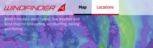
You’ll find the “Locations” feature in the top left corner, right beside the Windfinder logo:
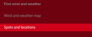
In the mobile web version, just click on the hamburger button and look for “Spots and locations” under “Find wind and weather”: